Cities and regions in Britain through hierarchical percolation

open-science

Our paper in Royal Society Open Science is published this week (April 6th 2016). This is one of the major themes in our ERC Project Mechanicity which has sought to explore how we can define and classify cities according to their size and performance using their underlying networks for the bonds that ties their parts together. There are many implications from this way of looking at things where we adopt the perspective of percolation theory for questions of globalisation, segregation, resilience and inequality. You can get the paper here – it is open source – and there is some detailed Supplementary Information that is pretty important for viewing the results.

The paper says:

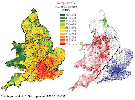
“Urban systems present hierarchical structures at many different scales. These are observed as administrative regional delimitations which are the outcome of complex geographical, political and historical processes which leave almost indelible footprints on infrastructure such as the street network. In this work, we uncover a set of hierarchies in Britain at different scales using percolation theory on the street network and on its intersections which are the primary points of interaction and urban agglomeration. At the larger scales, the observed hierarchical structures can be interpreted as regional fractures of Britain, observed in various forms, from natural boundaries, such as National Parks, to regional divisions based on social class and wealth such as the well-known North– South divide. At smaller scales, cities are generated through recursive percolations on each of the emerging regional clusters. We examine the evolution of the morphology of the system as a whole, by measuring the fractal dimension of the clusters at each distance threshold in the percolation. We observe that this reaches a maximum plateau at a specific distance. The clusters defined at this distance threshold are in excellent correspondence with the boundaries of cities recovered from satellite images, and from previous methods
using population density.”

We have developed quite a few explorations of cities using these ideas and we posted a somewhat oblique comment on how these results related to different electoral voting in the General Election last May. There is an early paper on this that is a complement to this one in the Arxiv.

Last but not least, I have given various presentations on our percolation and allometric city size work but here is a recent powerpoint that contains more information to some extent – or at least different information that relates to our work on the UK with some hints of how we might apply it elsewhere – as in Europe for example.


Posted in allometry, city size, Complexity, Economies of scale, Networks, Scaling | Leave a comment

A City is Not a Tree: 50th Anniversary Edition

Tree-alexander

A really nice idea. Michael Mehaffy has put together a superb collection of comments on Chris Alexander’s famous 1965 paper “A City is Not a Tree”. The comments which are presented in slightly longer papers and shorter contributions are from those (like me) who were and continue to be much influenced by his writings. I can’t reproduce the copy here but urge you to take a look at it somehow – click here for Amazon.com link – it is a very nicely presented paperback book. I quote from the blurb:

‘With new commentaries by leading urban scholars including Mike Batty, Luis Bettencourt, Howard Davis, and Bill Hillier. In 1965, the architect and design theorist Christopher Alexander published a landmark theoretical critique of modern urban design, and by extension, modern design in general. His critique was different from others of the day in that it was not based on a social or political argument, but on a structural analysis, rooted in then-emerging insights from the fields of mathematics and cognition. Here, published again on its fiftieth anniversary, is Alexander’s classic text, together with new interpretive commentaries and discussions by leading theorists and practitioners. This volume is destined to become an invaluable resource for a new generation of students and practitioners. “One of the classic references in the literature of the built environment and associated fields.”- Resource for Urban Design Information (rudi.net)”At a time of increasing concern over the adequacy of design methods, “A City is not a Tree” broke open and reoriented the debate.”- Charles Jencks and Karl Kropf “It pointed clearly to a change in the way we need to think about cities.” – Bill Hillier, Chairman of the Bartlett School of Graduate Studies, University College London “Remains a landmark in our thinking about cities and design…It is a new beginning — for Alexander and for urbanism — to discover what the city really is.” – Luis Bettencourt, Santa Fe Institute’

Enjoy, and Read

Posted in allometry, Complexity, Emergence, Hierarchy, power laws, Scaling | Leave a comment

A multilevel portrait of shrinking urban Russia

Shrinking Russia

A really nice article from Clementine Cottineau, one of our researchers, on how Russia is shrinking (Read in English or French, from Espace Populations SociétésTechniques that we may be able to apply in our new Digital Economies research project to shrinking Britain, in parts. She says and I quote from the abstract: “The demographic shrinkage of Russia, as measured by harmonised data at different geographical scales, appears unique in comparison with any other example in time and around the world. Using multivariate and multilevel statistical analysis, we show that shrinkage in cities is associated with different urban functions, and that these functions are distributed unevenly in the Russian territory. This sophisticated description of urban and regional attributes of shrinkage allows to gain insights on the probable consequences of different demographic policies in tomorrow’s Russia.”

Enjoy click here or above to get the article online

Posted in city size, Economies of scale, Hierarchy, Scaling | Leave a comment