In researching for my talk at Peter Hall’s 80th Birthday Symposium this coming Monday in UCL’s Darwin Lecture Theatre, I came across Raymond Unwin’s book Town Planning in Practice – An Introduction to the Art of Designing Cities and Suburbs (Fisher-Unwin, London) first published in 1909. In fact, Raymond Unwin might have been the first town planning professor in UCL for he was certainly connected to the College before Stanley Adshead took the first chair in 1914 but this alternative history is buried in the mists of time.
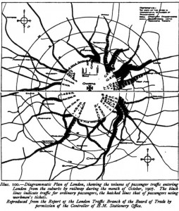
In Unwin’s book which as its name suggests is a work of ‘art’ not ‘science’ in the sense of our meaning of Science of Cities, there are some forerunners of our science in the map reproduced above from a 1906 Board of Trade Report on London’s Railways, Note the flow diagram, showing a much greater flow from the east and north east than there is today. But not the radial shape so characteristic still of our large cities everywhere. Of course on one of my blogs I traced the first flow map like this to Henry Harness in 1837 and then there was Charles Minard and his famous maps in the middle 19th century but the above is as good as its gets in terms of flows. Unwin’s book has been digitised by Google and you can get it online.

